
WordPress plugin
Interactive US Map – Create Clickable & Customizable U.S. Maps
Create engaging Interactive United States Maps in WordPress for free. It's easy to install, simple, and highly customizable.
- Active installs
- 300+
- Rating
- 5.0 / 5
- Version
- 3.4.8
- Last updated
- Aug 25, 2026
- Tested up to
- WordPress 7.1.5
- Requires
- WP 3.3 · PHP 5.3.3
Health check
Is Interactive US Map – Create Clickable & Customizable U.S. Maps safe to rely on?
Our reading of the public WordPress.org data: maintenance, compatibility, ratings and support.
Actively maintained
Last updated on August 25, 2026. Regular updates usually mean bugs and security reports get fixed.
Tested with current WordPress
The author has tested it up to WordPress 7.1.5.
Few ratings so far
Only 5 ratings on WordPress.org, so the average is not yet a reliable signal.
Requires PHP 5.3.3 or newer
Check your hosting PHP version before installing. Modern PHP is faster and receives security fixes.
Rank tracker
Where Interactive US Map ranks in WordPress.org search
Its position in WordPress.org plugin search for its tags and name, refreshed weekly so you can see how its visibility changes.
| Keyword | Position | Change | Trend | Current #1 |
|---|---|---|---|---|
| clickable maps | ||||
| interactive map | ||||
| interactive maps | ||||
| us map | ||||
| usa map | ||||
| interactive us map |
Checked against the top 100 WordPress.org search results.
Overview
What Interactive US Map – Create Clickable & Customizable U.S. Maps does
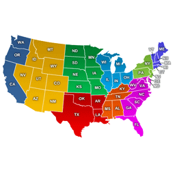
Using this free USA interactive map plugin for WordPress, you can easily display interactive US maps regions in different colors. It allows you to add a clickable US map that can open a URL or display more information when users click on a particular area of the map.
Looking for an Interactive US Map With States? Check Out Our US Interactive Map for Websites.
This free plugin allows you to use the rich visual or text editor to add the content to show information for different purposes. For example, branch/dealer network, sales regions, and delivery locations. You may also use it to make interactive infographics and present statistical data in a much engaging way with a tooltip on hover.
The plugin makes your interactive map of the United States look outstanding.
All the Essential Features Available in the Free Plugin
Works on iOS/Android devices.
Easy embedding by a shortcode.
Description from the author's listing. Read the full listing on WordPress.org
Screenshots
Interactive US Map – Create Clickable & Customizable U.S. Maps in action


FAQ
Interactive US Map – Create Clickable & Customizable U.S. Maps: questions and answers
What is Interactive US Map – Create Clickable & Customizable U.S. Maps?
Interactive US Map – Create Clickable & Customizable U.S. Maps is a WordPress plugin by html5maps. Create engaging Interactive United States Maps in WordPress for free. It's easy to install, simple, and highly customizable.
Is Interactive US Map – Create Clickable & Customizable U.S. Maps free?
Interactive US Map – Create Clickable & Customizable U.S. Maps is listed in the WordPress.org plugin directory, so the version there is free to download and use. Some authors also sell paid add-ons or a premium edition with more features and support.
How many websites use Interactive US Map – Create Clickable & Customizable U.S. Maps?
WordPress.org reports 300+ active installations of Interactive US Map – Create Clickable & Customizable U.S. Maps. That figure counts sites running the WordPress.org version and is rounded down by WordPress.org.
Is Interactive US Map – Create Clickable & Customizable U.S. Maps still maintained?
Interactive US Map – Create Clickable & Customizable U.S. Maps was last updated on August 25, 2026. The current version is 3.4.8. Check the changelog on WordPress.org and test updates on a staging site before applying them to a live site.
What does Interactive US Map – Create Clickable & Customizable U.S. Maps require?
Interactive US Map – Create Clickable & Customizable U.S. Maps requires WordPress 3.3 or newer and PHP 5.3.3 or newer. It has been tested up to WordPress 7.1.5.
Can Codefreex set up or customize Interactive US Map – Create Clickable & Customizable U.S. Maps?
Yes. Codefreex installs, configures and customizes WordPress plugins including Interactive US Map – Create Clickable & Customizable U.S. Maps, fixes conflicts and performance problems, and builds custom features when a plugin does not do exactly what you need. Send your site URL for a free review.
Free expert review
Need Interactive US Map – Create Clickable & Customizable U.S. Maps set up, customized or fixed?
Tell us about your site and what you need this plugin to do. A senior WordPress developer replies within one business day with a plan and a quote.